


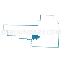
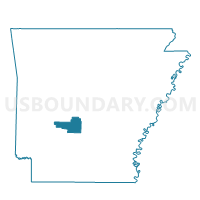
Upper Prairie Voting District, Hot Spring County, Arkansas
About
Outline

Summary
| Unique Area Identifier | 526613 |
| Name | Upper Prairie Voting District |
| County | Hot Spring County |
| State | Arkansas |
| Area (square miles) | 14.02 |
| Land Area (square miles) | 13.99 |
| Water Area (square miles) | 0.04 |
| % of Land Area | 99.75 |
| % of Water Area | 0.25 |
| Latitude of the Internal Point | 34.26410240 |
| Longtitude of the Internal Point | -92.98546480 |
Maps

Graphs
Select a template below for downloading or customizing gragh for Upper Prairie Voting District, Hot Spring County, Arkansas


Neighbors
Neighoring Voting District (by Name) Neighboring Voting District on the Map
- Antioch Voting District, Hot Spring County, AR
- Lone Hill Voting District, Hot Spring County, AR
- Lower Prairie Voting District, Hot Spring County, AR
- Midway Voting District, Hot Spring County, AR
- Montgomery Voting District, Hot Spring County, AR
- Ouachita Voting District, Hot Spring County, AR
Top 10 Neighboring County Subdivision (by Population) Neighboring County Subdivision on the Map
- Montgomery township, Hot Spring County, AR (1,209)
- Prairie township, Hot Spring County, AR (1,111)
- Midway township, Hot Spring County, AR (914)
- Lone Hill township, Hot Spring County, AR (857)
- Ouachita township, Hot Spring County, AR (660)
- Antioch township, Hot Spring County, AR (432)
Top 10 Neighboring Place (by Population) Neighboring Place on the Map
Top 10 Neighboring Unified School District (by Population) Neighboring Unified School District on the Map
- Malvern Special School District, AR (18,325)
- Bismarck Public Schools, AR (6,205)
- Ouachita School District, AR (1,992)